
The Colorado National Monument, although less well known than Grand Canyon National Park, can provide a visitor with similar vistas, but less crowded visitor services. It can be entered through the Colorado towns of Grand Junction or Fruita.

I am giving the victory sign in this photograph, because it was my first time to use my good-for-a-lifetime National Park Pass! And this was a great place to take my pass for its first-ever expedition! Colorado National Monument covers 32 square miles of rugged, up-and-down terrain, and preserves one of the grand landscapes of the American West.

When a visitor takes the 23 mile Rim Rock Drive, they will drive a well-maintained highway that skirts the edge of the canyon walls. There will be many opportunities to stop your car, and enjoy the sweeping vistas of the valley below, as seen in this photograph.

In addition to the panorama of deep, sheer-sided canyons, you can also see numerous higher rock towers.

Exhibit kiosks at the pull-outs along the drive, provide information about the natural and human history of the park. The kiosks tell us that the Colorado National Monument is part of the greater Colorado Plateau, which also embraces geologic wonders like the Grand Canyon, Bryce Canyon, and Arches national parks.

The Rim Rock Drive is popular with bicyclists, so automobile drivers need to be especially vigilant and proceed with caution through all sections of the drive

There are numerous places along the drive that visitors can stop for a picnic lunch, but these covered tables at the Visitor's Center are especially popular, because one can enjoy the magnificent views, while sitting at a comfortable picnic table, under the shade of the pavilion.

Some of the pull outs will place you just a few feet from the canyons edge, while at other pull out locations (such as the one showing the people in this photograph), the visitor will need to walk a short distance to be at the canyon's edge.

Most visitors explore the areas reached by a short hike of .25 mile to one mile in length.

However, there are longer hiking trails available, for those who want a real challenge. I have highlighted such a trail in this photograph, where you can see the numerous switchbacks in the trail, that takes a hiker from the top of the canyon to the bottom, and out a different exit. The longest hike listed in the park brochure is 8.5 miles.

This is a section of the park called "Monument Canyon", and the three cone-shaped formations are called the "Coke Ovens" because of their resemblance to early structures used to make charcoal. These formations of colorful rock domes were created by the natural sculpting forces of wind, water, and ice.

Differences in the characteristics of the many layers of sandstone, shale, and other sedimentary rocks of the area help determine what form the rocks take. The very photogenic colors--- reds, purples, oranges, and browns---in the stone formations are created by iron and other minerals in the rock.

There are three tunnels along the Rim Rock Drive, so if you have a high-clearance vehicle, you will want to check with park officials to be sure your vehicle will pass through the tunnels.

The first I ever heard of Colorado National Monument was about ten years ago, when I was a guest of the Grand Junction Convention and Visitors Bureau (
www.visitgrandjunction.com ). Their staff member, Barbara Bowman, brought our group to the Book Cliffs View shelter for a picnic breakfast, as the sun was coming up over the horizon. It was a magnificent and memorable occasion, and I have been singing the praises of this location ever since that experience! It is noteworthy that the entire Rim Rock Drive is a National Historic District because many of the early facilities were constructed by Public Works Administration and the CCC (Civilian Conservation Corps).

I took this photo of the placard that overlooks Independence Monument to illustrate an Independence Day tradition that takes place on Independence Monument. Independence Monument is the tallest free standing rock formation in the park, and is the site where the flag of the United States of America is raised each July 4. The tradition started over 100 years ago by legendary early park promoter John Otto. Today, members of the Mesa County Technical Search and Rescue team continue the tradition of raising the flag there every July 4th. The individual rock climbers scale Independence Monument. After the last climber reaches the top, the climbing team will gather to raise the flag. The best places to view this flag raising ceremony are the Independence Monument View Overlook and Otto's Trail. There are other areas of the park that allow rock climbing, and those interested would need to check with park officials and website (
www.nps.gov/colm/index.htm ) before proceeding, to get the most up to date information.

The Colorado National Monument has an outstanding Visitor Center, with information, exhibits, audiovisual programs, and a gift shop. They also carry books, maps, and other publications in keeping with the National Park system. Staff is on hand to answer questions and help you plan your visit. You will also see their schedules of guided walks and talks that are posted in the summer. I had the great pleasure at the time of my recent trip, to watch the little boys pictured in this photo, complete their requirements to become a "junior park ranger", verified with a certifying stamp, on their certificate. It made me wish I was a little younger, so I could be a "junior ranger" as well, and enjoy the applause of everyone in the building, when the award was bestowed!

In the exhibits section of the Visitor Center, you will learn that the 23 mile Rim Rock Drive was built almost entirely using picks, shovels, and sheer muscle strength to remove massive rocks and debris.

Seeing the name of this hiking trail reminded me of a memory verse I am trying to learn in a class I lead at my church (
www.myfbcmh.com ). It is a part of the mental component of a healthy living program you can learn more about at
www.FirstPlace4Health.com . The verse is a reminder that when we get the "cold shivers", God is with us: "The LORD your God is with you, he is mighty to save. He will take great delight in you, he will quiet you with his love, he will rejoice over you with singing." Zephaniah 3:17

This weathered old evergreen tree along a hiking trail was probably present in 1906 when John Otto first saw the canyon, during a visit to Grand Junction. He made it his goal to have the area accepted as a national park. The following story is told in the park brochure: "...he loved the land so much that he campaigned tirelessly for it to be set aside as a national park. Urged by Otto, the citizens of Grand Junction deluged politicians in Washington, D.C., with letters and petitions in support of the proposal. Meanwhile, Otto built miles of tortuous trails through the proposed park area so others could appreciate its beauty. And he did it all without hope of any personal gain. But in 1911, Otto's dream came true; Colorado National Monument was established. Otto was rewarded by being named the park's caretaker, a job he gladly did until 1927, for $1 a month."

I am hoping these photos will make you want to include a trip to the Colorado National Monument on your "bucket list". It is a place that will give you great delight, quiet you with its loving beauty, make you want to rejoice with singing, and give you MILES OF SMILES!! Tricia

 One of the great things about being a part of the Arkansas Master Naturalist program (www.home.arkansasmasternaturalists.org ) is the opportunity to expand your knowledge through training, on all things related to the outdoors. Since we have to have continuing education to maintain our certification, I had participated in a day-long workshop earlier in the year, sponsored by a nationwide nonprofit, called Project Learning Tree ( www.plt.org ). Completion of that training enabled me to be a part of the 2013 Teacher Conservation Tour, sponsored by the Arkansas Forestry Foundation, in conjunction with Project Learning Tree. The Conservation Tour was headquartered at the state's only four-year forestry school---The University of Arkansas at Monticello. This photo collage shows some of the other folks in the group, on our first assignment, which involved going out on the campus and finding examples of the different kinds of leaves we had learned about in the classroom.
 This photo collage shows our state's only female soil scientist. She spoke to our group about how various soil types affects what can be grown on a particular piece of ground. She showed us the custom-designed truck she uses in the field, to take her soil samples. The photo on the right side of the collage shows the special device attached to the truck body that she can use to bore down into the ground, to bring up a soil sample, that can be taken into a laboratory for testing.
 Our group traveled to nearby Lake Monticello to study water quality. This photo shows me with one of the "kick nets" that is used to gather up samples of the microinvertebrae that live in water, so that they can be looked at under the microscope and magnifying glass. By studying which tiny critters live in a body of water, the quality of the water can be determined. It is sort of like the "canary in the mine" test of a hundred years ago, that was used to warn miners that air quality was bad.
 Once we had our water samples, we divided them into white basins, and further, into white ice cube trays. This enabled us to see movement in the water, and determine what living creatures we had collected. We had a waterproof, illustrated "key" that would help us give a name to what we saw, and accurately record our data.
  We learned another way to measure water quality, which is by measuring the weight and length of fish in the water. To make this more of a scientific process (as opposed to just putting a hook and worm in the water to see what bites on it), the Arkansas Department of Environmental Quality has a custom-built boat with two poles on the front. These two poles are connected to an electric generator that can send a mild electric shock into the water, and stun the fish in the immediate area. Then the people in the front of the boat can use their nets to scoop up the stunned fish that float to the surface. They can be measured, then put into the holding tank. After they "revive", they are released back into the lake. While I was participating in this activity, I realized that if I had followed through with the college major I declared when I was a freshman at the University of Arkansas---Marine Biology---I would have been doing this my entire working career. Although I switched majors my sophomore year, to Human Nutrition, it is an interesting thought to ponder!
 Our group trekked into the pine forests on several occasions, as shown in this photo. Fortunately, bug spray was included in the price of the event, and I made sure I applied it liberally!
 Our group had foresters from both government agencies and private companies, teach us about how a pine forest is monitored, thinned, and studied, to produce the best crop possible. Thinning of a pine forest is necessary so that the trees will have adequate sun and soil nutrients to grow to maturity. The smaller pine trees that are taken out can be used for making paper and other wood products.
 I liked this pine forest better than the one shown in the photo above, because it belonged to a private landowner, who had a well-worn hiking trail through it !
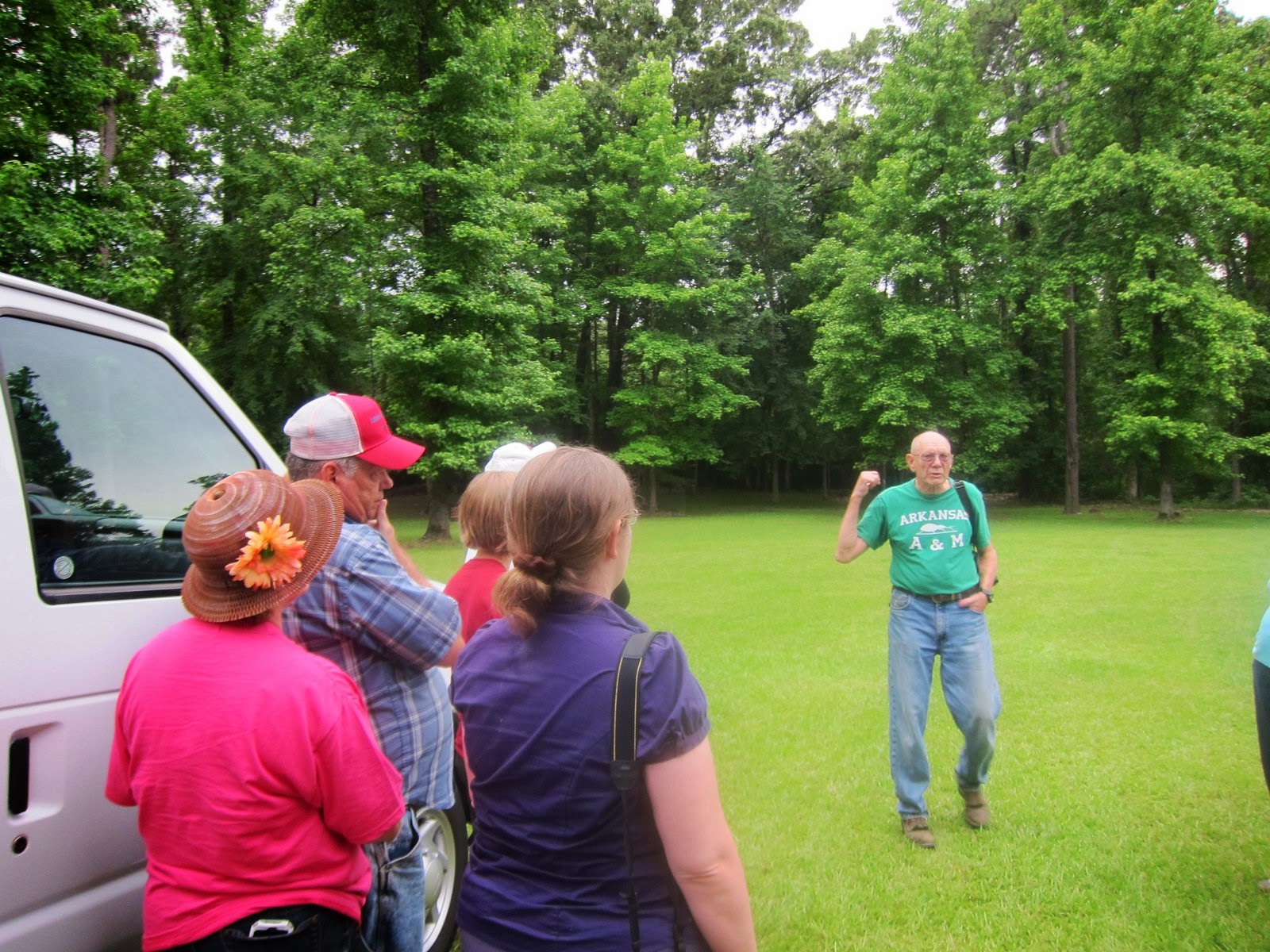 That private landowner was Mr. Kelly Koonce, shown in this photo with his vintage college tee shirt. When he graduated from the Monticello college with his degree, back in the last century, it was called the Arkansas A&M.
 Mr. Koonce built his home, shown in this photo, from lumber that he cut down and milled, right from his very own property.
 He also built a second building, which he said that he and his wife used to host church groups and forestry student groups, such as ours. We had a delicious BBQ meal in this picturesque location, which he preceded with a moving prayer of thanks to God, for the abundance of God's creation, that we all enjoyed that night.
 Mr. Koonce was proud to show us this dining table he made from two different kinds of pine trees that grew on his property. He pointed out that the difference in color of the wood, is due to it being from two different species of trees.
 Our group also had to opportunity to visit an actual, active logging site. Heavy equipment is required for today's timber harvests, and the operator stopped long enough for us to look inside his very high-tech piece of machinery.
 The head of this logging company (shown in the red shirt) said his company has four generations of loggers in it. His ancestors started with a handheld long saw, and now the operation has grown to have millions of dollars invested in equipment.
 I was fascinated by how quickly this special piece of equipment was able to load the stripped down logs, on to the truck waiting to take them to the lumber mill.
 Our lunch meal on the day we visited the logging operation was a "down home" cafe in Fordyce, called "Red's". It was a delicious example of Southern food, and hit the spot for this group of hungry "lumberjacks" and "lumberjills"!
 We had the good fortune to be able to tour the Georgia Pacific OSB (Oriented Strand Board) Mill in Fordyce. Although photos were not allowed inside the mill, we were able to take photos of the logging trucks getting on the truck scale, as they pulled into the mill, to unload their cargo.
 In this photo, one can see the stacks of OSB covered in white, for protection from the elements, while it is being shipped to a lumberyard near you!
 All this study about Arkansas forests made me realize that the lumber we use, comes from harvesting a "crop", just as we would harvest a corn "crop". From a tiny seedling, no bigger than the toe of my shoe, to a soaring pine tree that is 25 years old, and ready to be harvested, a transformation process is taking place. This "transforming" image is a visual aid to help me learn my First Place 4 Health memory verse (www.FirstPlace4Health.com ) that says "And we, who with unveiled faces all reflect the Lord's glory, are being transformed into his likeness with ever-increasing glory, which comes from the Lord, who is the Spirit." (2 Corinthians 3:18) . If you would like to learn more about all the resources available to help you understand land conservation and forest management, just click on www.arkforests.org . Seeing all those trees will give you "miles of smiles"! Tricia


