

 Our group stayed at the incredibly beautiful Cypress Bend Resort and Golf Club. The photo showing me, with uplifted arms in gratitude, was taken on the golf course we visited, and the photo below shows our group having an outdoor supper at the pavilion overlooking the lake:If you want to watch the sun go down over Texas, without actually being in Texas, this is the place to do it! Sunsets always seem to be more stunning when there is a body of water in the foreground, and who could find a prettier inland location for photography, than this body of water that separates Louisiana from Texas!

There is only one national forest in Louisiana (Kisatchie National Forest), and it has a limestone cave feature that is unique to the area. It is accessed by an easy trail, shown below. When I am out hiking, I like to get photos of people walking the trails under overhanging rock ledges, so I asked the person behind me to snap this photo of me, (since I was not quick enough to get someone in front of me to pose for a photo.)

 No one in our group ventured back into the cave any further than the opening, seeing as how this was not a spelunking expedition. However, the forest service personnel said it was not a very big cave.
  There was a spacious parking lot at the trailhead for Wolf Rock Cave, that easily accommodated our large motorcoach. And in a true gesture of Louisiana hospitality, the forest service had a table of snacks and beverages for us, as well as a clean port-o-potty with hand-washing facilities. This was a welcome sight, as the cave is located several miles off the pavement, on a gravel, forest service road.
A very popular town in this area is Natchitoches (pronounced Nack-a-tish). Since the name of the town is not pronounced the way it is spelled, I thought it was very helpful that there was a big sign in the visitor center that explained the pronunciation, and also a map on the wall that shows Natchitoches is just a short drive into Louisiana, from the southern border of Arkansas!

This photo I took of the rowing skiffs, is a reminder to say that Cane River Lake is the site of college rowing competitions, as well as Dragon Boat Races.

I saw the photo below on the local college (Northwestern State University) social media page, recognizing their Women's 4+ rowing team that brought home the championship in a rowing competition in May, 2021.

The city of Natchitoches, whose tagline is "Louisiana's Oldest City", has numerous types of lodging, and these are listed on their website at www.Natchitoches.com, or you can phone their office directly at 1-800-259-1714. Some of the lodging properties are directly on the waterfront, such as "CanDi on the Cane Guesthouse", pictured below:


The Cane River Lake was formed whenever the Red River shifted its course, brought on by a gigantic, 160-mile-long, log jam, causing an oxbow lake to form. The massive log jam was known as "The Great Raft". In the 1830's, "snag boats" started trying to clear the log jam raft. But soon after the raft was cleared, the meandering river began to change the course of its main channel. The result was a new channel which cut across a bend , over four miles north of Natchitoches. Afterwards, steamboat access to Natchitoches was difficult, and ultimately impossible. By the beginning of the 20th century, dams were built to separate the old channel from the new, thus forming "Cane River Lake". So now, the body of water that passes through downtown Natchitoches is a lake, but has the characteristics of a stream. It averages only about 250 feet in width. The use of dams to control the depth and "current" of the lake made it possible for the city of Natichitoches to open up a beautiful, renovated riverfront part in 2017, that is less prone to flooding.

 Our group had the pleasure of taking a boat ride on the lake, aboard the"Cane River Queen" vessel. We took a leisurely cruise down the lake and back, and enjoyed seeing several different types of wildlife along the way. You can find out more about the many services they offer, by visiting their website at www.caneriverqueen.org
 I was intrigued with the beauty of the riverfront park, including the red brick sidewalks, the luscious hanging baskets full of colorful blooms, vintage-style lampposts, and park benches.
  The expansive canopy of the live oak trees provides shade for the park, and there are clean public restrooms that are easily accessible. (the person in photo is walking towards the public restrooms at the end of the sidewalk)

Kayaks, both those powered by paddles, and those powered by foot pedals, are available for rent in downtown Natchitoches at the Cane River Paddle and Pedal Concession. They also rent standup paddleboards, You can find out more by phoning them at 318-527-0066. I am posting these photos of paddling possibilities in this area, in hopes of inspiring my kayaking buddies to come on a group trip to this area!

If you look at the photo below, I hope you will notice the bold architectural statement made around the ascending staircase. This is the Louisiana Sports Hall of Fame and Northwest Louisiana History Museum, that is known as much for its stunning architecture, as its historic exhibits. You can read about the history of the area by visiting www.LouisianaStateMuseum.org


Another attraction you will not want to miss when you are in Natchitoches, is the Fort St. Jean Baptiste State Historic Site, one of three state historic sites in the area.


Another reason this would be a good trip for those who enjoy paddle sports, is that there is a popular lake in Natchitoches, called Sibley Lake (shown here). Whenever I saw the kayaks on the shore at the restaurant where we dined, I was visualizing a "repeat performance" of a paddling excursion our kayaking group took in Gulf Shores, Alabama. We started our adventure on a canal near our lodging property, and then paddled about a mile, to a popular restaurant along the waterfront, stowing our kayaks on the shore---similar to the ones shown in the photo I took. We had a delicious seafood lunch, then worked off the calories by paddling back to our launch site! It was a fun experience!


My photos and comments in this article have barely scratched the surface of the numerous activities that await you when you visit the southwest section of Louisiana, known as "No Man's Land"! You can find out more from their website by visiting www.VisitNoMansLand.com and for information about other areas of Louisiana, check out www.LouisianaTravel.com or phone the Louisiana Department of Tourism at 225-342-9282. I predict a visit to these charming locations will give you "MILES OF SMILES"!!
 St. Andrews State Park ( www.floridastateparks.org ) is located in Bay County, in Panama City Beach, Florida. The park has 1,200 acres, and gets its name because it is located on St. Andrews Bay, a 69,000 acre estuary located in northwest Florida.
 This photo shows the kayaks that can be rented for paddling around the adjacent Grand Lagoon, shown in background.
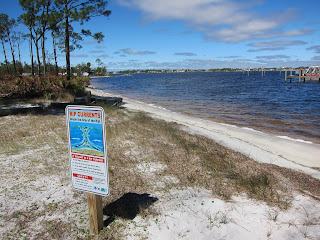 Swimming, snorkeling, and scuba diving is allowed in the park, but participants in those sports are cautioned about the presence of RIP CURRENTS in this type of water environment.
 Bicycle rentals are also available, and there are many areas throughout the (mostly flat) state park, that provide pleasant locations for pedaling.
 The sign at the top of this dock indicates this is the boarding location for the park's shuttle to Shell Island. Shell Island is a seven-mile long barrier island that is part of the park, but has no bridges leading to it, so boating is the way people choose to access it.

 Because the park has five distinct ecological landscapes within its boundaries, birders have opportunities to see a larger variety of species. The five habitats are undisturbed pine hammocks, sugar sand beaches, native coastal scrub and wetlands, a lake, and inland shallow water tidal habitat on the lower Grand Lagoon.
  Thankfully, boardwalks have been built to provide visitors access to the "inner reaches" of the wetlands.
 At the end of the board walk is a viewing platform, with benches, and interpretive panels to tell visitors what wildlife they might see in this particular habitat.


 It is easy to see why there were many accidents in saw mill of the past, as there was no protection for the workers from the spinning saw blade.
 Although no special gear is required for a hike, a good set of eyes that are alert to walking through alligator habitat, IS a requirement! I have read enough stories about people who were killed in Florida from an alligator attack, that I take these warning signs very seriously!
 I always take a photo of the sign that shows the trail map, before I start out on a hike. That way I can refer to it, if I get confused as to which path to take. Also, signs like this will usually tell you the total length of the trail and how long it generally takes to walk through it.
  I was intrigued by this scene of the scrub brush and trees, forming a complete arch and canopy, for the bench along the trail.


