
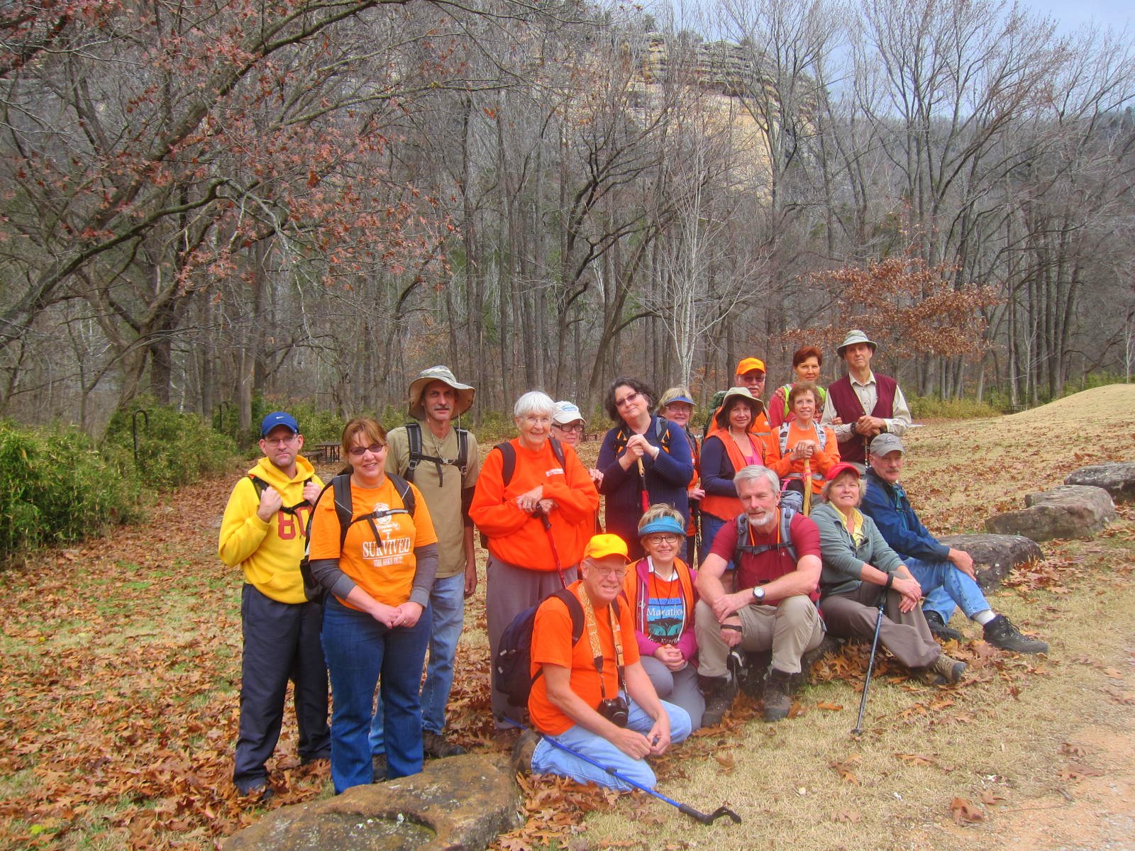
A group from the North Central Chapter of the Arkansas Master Naturalists (
www.Home.ArkansasMasterNaturalists.org ) was blessed with "short sleeve weather" on the first day of December, as they gathered at Kyle's Landing on the Buffalo National River in northwest Arkansas, for the purpose of hiking Indian Creek Trail, which is one of several trails in the area.

Since most hikers these days are either carrying a phone that takes photos, or a camera, it is always a good idea to take a photo of the map shown on a sign at the beginning of a trail head. This can serve not only to identify the area when you are reviewing the photographs months later, but also as a reference in the event you were to get lost along the trail.

There is no official trail through the area, because of the constantly varying water levels in Indian Creek. On the day our group went through, the creek bed was mostly dry, and covered with leaves. The trek is about five miles, round trip.

There are several places along the stream bed where the water flow goes underground, then re-emerges hundreds of yards away. Seeing some of the places where the water was coming out of rocks reminded me of the verse in Exodus 17:6 where God tells Moses, "Strike the rock, and water will come out of it for the people to drink."

There were still a few deep pools of water along the creek bed, and there are various ways to try to get around these pools, depending on whether a person wants to climb up and around the "obstacle", or risk traversing the slippery rock sides of the pool. One of the hikers in our group, took an unexpected slip into the cold water, trying to navigate the bluff line in this photograph. It is a reminder that it does not hurt to carry a change of clothes, and your electronic devices in zip lock bags!

There was alot of communicating between hikers above the creek, with those below on the creek bed, sharing information about the best way to proceed. Sometimes, if you were up high, you could see a passage way that was not visible to those at creek bed level.

When the water is low, it is easy to find scenic spots for lunch, where everyone can sit down, even if your group is large, like ours was.

Another advantage of going when the water is low, is that it enables you to see the interesting rock formations that would be covered up with heavy spring rains.

There are a couple of caves along the Indian Creek hike, but the National Park Service has posted these notices, with the hopes of protecting the cave inhabitants from devastating diseases, carried by humans. In particular, there is concern that a malady called "White Nose Syndrome" is destroying entire bat colonies in the eastern United States. (So when you hear someone talk about "White Nose Syndrome", they are probably NOT referring to the lifeguard whose nose is plastered with white zinc oxide to prevent sunburn!)

Perhaps you have read about hiking the slot canyons of Utah, but the Arkansas Ozarks also has some moss-covered examples of slot canyons, as well! The hiker with the orange shirt shown in the photo, is dwarfed on both sides by the towering limestone bluffs that line both sides of the creek bed near the area where our group turned around.

At the spot where the creek bed "dead ends", there is a a very tall bluff line, that some members of our group decided to climb. One book I read said that the National Park Service reports more injuries in the Indian Creek area, than any of their other wilderness sections. And in fact, one of our members did come out with their arm in a makeshift sling, after slipping on the limestone, and catching their fall by landing quite hard on their hand.

When climbers are scaling the various levels of the bluff line, the crumbling rock ledges often break off, sending a rock slide upon those below. Hence, another reason to use extreme caution, even as a spectator in this area. I did not try scaling this bluff, but I was still able to see part of the "Eye of the Needle". In the upper left corner of this photo, there is a small blue dot. That is actually a very large opening in the bluff, where daylight (and people) can get through.

Some of our members used a (very old looking) rope that they found tied to a tree, to access the upper levels of the box canyon. If scaling the summit is important to you, it is probably wise to carry your own rope, so that you will know that it is strong, and not weakened by being out in the harsh environment, in constant use.

It is easy to understand why photographers like for their subjects to wear brightly-colored shirts when climbing, so the camera can more readily "capture" their whereabouts. For example, the three men in dark clothes, two thirds of the way up the bluff, are barely visible against the muted tones of the stone and vegetation.

The guys were not the only ones who did some climbing! This photo shows my friend Joan on one of the Indian Creek bluffs, and she is a good example of wearing bright colors, to stand out against the stone.

Even I found myself clutching the slick, moss-covered rock at some spots along the creek!

Of course, when the camera is turned in its proper, horizontal position, you can see that the previous, so-called "climbing photo" of me, was trick photography, taught to me by my rock-climbing son!

As Master Naturalists, people in our group are not only looking at the "macro" scenery, but the "micro" scenery as well. In this picture, Dwan is shown getting a photo of an itsy-bitsy mushroom that caught her eye, as it was different from any that she had ever seen before.

The North Central Chapter of the Arkansas Master Naturalists will be starting a new "semester" of training in January, 2013. If you are interested in learning more about the activities of the local chapter, or enrolling in the next session of training, you may phone the Bull Shoals-White River State park at 870-445-3629. Being a part of this very worthwhile organization is sure to bring you "miles of smiles"!! Tricia

 A group from the North Central Chapter of the Arkansas Master Naturalists ( www.Home.ArkansasMasterNaturalists.org ) was blessed with "short sleeve weather" on the first day of December, as they gathered at Kyle's Landing on the Buffalo National River in northwest Arkansas, for the purpose of hiking Indian Creek Trail, which is one of several trails in the area.
 Since most hikers these days are either carrying a phone that takes photos, or a camera, it is always a good idea to take a photo of the map shown on a sign at the beginning of a trail head. This can serve not only to identify the area when you are reviewing the photographs months later, but also as a reference in the event you were to get lost along the trail.
 There is no official trail through the area, because of the constantly varying water levels in Indian Creek. On the day our group went through, the creek bed was mostly dry, and covered with leaves. The trek is about five miles, round trip.
 There are several places along the stream bed where the water flow goes underground, then re-emerges hundreds of yards away. Seeing some of the places where the water was coming out of rocks reminded me of the verse in Exodus 17:6 where God tells Moses, "Strike the rock, and water will come out of it for the people to drink."
 There were still a few deep pools of water along the creek bed, and there are various ways to try to get around these pools, depending on whether a person wants to climb up and around the "obstacle", or risk traversing the slippery rock sides of the pool. One of the hikers in our group, took an unexpected slip into the cold water, trying to navigate the bluff line in this photograph. It is a reminder that it does not hurt to carry a change of clothes, and your electronic devices in zip lock bags!
 There was alot of communicating between hikers above the creek, with those below on the creek bed, sharing information about the best way to proceed. Sometimes, if you were up high, you could see a passage way that was not visible to those at creek bed level.
 When the water is low, it is easy to find scenic spots for lunch, where everyone can sit down, even if your group is large, like ours was.
 Another advantage of going when the water is low, is that it enables you to see the interesting rock formations that would be covered up with heavy spring rains.
 There are a couple of caves along the Indian Creek hike, but the National Park Service has posted these notices, with the hopes of protecting the cave inhabitants from devastating diseases, carried by humans. In particular, there is concern that a malady called "White Nose Syndrome" is destroying entire bat colonies in the eastern United States. (So when you hear someone talk about "White Nose Syndrome", they are probably NOT referring to the lifeguard whose nose is plastered with white zinc oxide to prevent sunburn!)
 Perhaps you have read about hiking the slot canyons of Utah, but the Arkansas Ozarks also has some moss-covered examples of slot canyons, as well! The hiker with the orange shirt shown in the photo, is dwarfed on both sides by the towering limestone bluffs that line both sides of the creek bed near the area where our group turned around.
 At the spot where the creek bed "dead ends", there is a a very tall bluff line, that some members of our group decided to climb. One book I read said that the National Park Service reports more injuries in the Indian Creek area, than any of their other wilderness sections. And in fact, one of our members did come out with their arm in a makeshift sling, after slipping on the limestone, and catching their fall by landing quite hard on their hand.
 When climbers are scaling the various levels of the bluff line, the crumbling rock ledges often break off, sending a rock slide upon those below. Hence, another reason to use extreme caution, even as a spectator in this area. I did not try scaling this bluff, but I was still able to see part of the "Eye of the Needle". In the upper left corner of this photo, there is a small blue dot. That is actually a very large opening in the bluff, where daylight (and people) can get through.
 Some of our members used a (very old looking) rope that they found tied to a tree, to access the upper levels of the box canyon. If scaling the summit is important to you, it is probably wise to carry your own rope, so that you will know that it is strong, and not weakened by being out in the harsh environment, in constant use.
  It is easy to understand why photographers like for their subjects to wear brightly-colored shirts when climbing, so the camera can more readily "capture" their whereabouts. For example, the three men in dark clothes, two thirds of the way up the bluff, are barely visible against the muted tones of the stone and vegetation.
 The guys were not the only ones who did some climbing! This photo shows my friend Joan on one of the Indian Creek bluffs, and she is a good example of wearing bright colors, to stand out against the stone.
 Even I found myself clutching the slick, moss-covered rock at some spots along the creek!
 Of course, when the camera is turned in its proper, horizontal position, you can see that the previous, so-called "climbing photo" of me, was trick photography, taught to me by my rock-climbing son!
 As Master Naturalists, people in our group are not only looking at the "macro" scenery, but the "micro" scenery as well. In this picture, Dwan is shown getting a photo of an itsy-bitsy mushroom that caught her eye, as it was different from any that she had ever seen before.
 The North Central Chapter of the Arkansas Master Naturalists will be starting a new "semester" of training in January, 2013. If you are interested in learning more about the activities of the local chapter, or enrolling in the next session of training, you may phone the Bull Shoals-White River State park at 870-445-3629. Being a part of this very worthwhile organization is sure to bring you "miles of smiles"!! Tricia
