This is the building and sign that you see, when you enter the campus of WOKA. The word "WOKA" is a reference to "the Waters of Oklahoma and Arkansas" Whitewater Park.

The original date of publication for my blog about WOKA was January 1, 2024, and I mentioned that I had the goal of returning to WOKA, when it was warmer, so that I could actually experience going through the whitewater, in a kayak. I achieved my goal, and this updated blog tells about that experience, which took place on July 15, 2024.
I was the first customer at the park that day, so I was able to park my white car very close to the rental concession:
Y arrived shortly thereafter, and also got a close parking space. The parking fee to enter WOKA is ten dollars, no matter how many people are in your vehicle, so if you want to reduce your expenses, carpooling is a consideration before you enter the park.
The first employee I talked to upon entering the park, was very helpful in telling me what I needed to know to get started. She is wearing one of the many logo items available for purchase at the park concession booth.
This photo shows my WHOyaker friends lining up to pay the rental fees and sign the waiver, that each individual must sign. Check the website at www.VisitWOKA to find out the current rental prices. All rentals come with a helmet and a life jacket, because no one can enter the water channel unless they have on a helmet, lifejacket, and secure footware. The park only accepts credit cards for payments--no cash or checks.

This photo below was taken from in front of the concession booth, closer to the water's edge. One can see my white car in the background. By having such a close parking spot, there was no need to pay the six dollar fee to rent secure storage for valuable items, as I could keep them in my car.
By arriving before 10 am, the sun was still somewhat low in the sky, so it gave a silver shimmer to the flowing waters of the whitewater park.
If one has their own whitewater-designed watercraft, life vest, and helmet--then no rental equipment would be necessary. Notice that the kayak in the photo below is a very short one, and the paddler is enclosed and surrounded by an "apron", that makes it possible for him to roll over, then paddle his way back to the upright position. It is not something I want to attempt!
Notice the paddler is completely submerged, in photo below: (thankfully, he was able to get himself upright!) Those who want to practice this maneuver frequently, are probably those who take advantage of season passes to the park.
Photo below is taking from center of walk way, and is looking towards the take out point. The sign says not to drag your kayak. Back home, I am able to carry my kayak, as it is very light. However, that was not the case for the WOKA inflatable kayak I rented. It was much heavier and bulkier. Since I am so short, I could not keep it off the ground by holding it with one hand, the way I can do for my kayak back home. I soon found out it takes two people to walk the kayak back to the start of the rapids!
Photo below is from the halfway point, looking upstream towards the beginning of the rapids. I read it is about a 1200 foot distance, which amounts to around one fourth mile. The ride down the waterway in your watercraft is great fun---the walk on the concrete (carrying your kayak!) back to the start---not so much.
In the photo below, one can see a blue round raft at the top of the waterfall on the right. There is a blue single-person kayak at the top of the waterfall on the left.
Photo below shows the type of inner tube and inflatable kayak that is available for rent at WOKA.
All of us crowded into one of the large, round rental rafts for a group photo. However, when this raft went down the waterway, there was never more than three adult ladies in it, and only one of the ladies had a paddle. We took turns trying it out, and it was definitely a thrill ride going over the waterfalls!
I was the first one to complete reading/signing the electronic waiver, and paying the rental fee, and hence, the first one to shoot the rapids in the inflatable kayak. The park employee advised me before I started, NOT to raise my arms above my head holding the paddle in a victorious gesture, when I was going over the waterfalls. She said I had a much better chance of making it through upright, if I kept my arms and paddle low, and thus keep my center of gravity low. I did as she suggested, but as soon as I successfully completed the course, I was raising my arms in gratitude! (Thank you to K for taking the photo below of me!)
K also took this photo of three of our ladies coming down in the round raft. Notice there is only one paddle in the group.
I had been watching the live cam on the WOKA website several days previous to our visit, and I noticed that sometimes two people were carrying two kayaks, as shown by two of our WHOyakers in photo below. Other times, two people were carrying one kayak and one innertube. To get the giant round rafts back to the starting point, most people were turning them on their side and rolling them.
I took photo below of K with her phone, which was in a waterproof case. The FAQ on the website advises against taking a phone onto the course, but as far as I know, the waterproof case protected K's phone.
K asked Y to take some photos with her phone, so Y used the opportunity to snap one of her famous selfies! That is me in the middle, and D on the far end.
This is another photo K took of me, expressing thanks to God that I was able to have this experience with a group of wonderful friends! It gave me "MILES OF SMILES'1
Remainder of photos are from 2023 "pre visit"
The photo below shows the entry gate cars must go through, to enter the park. It only accepts credit cards, as the park is listed as a "cashless" facility. As you can see from the photo I took through my windshield, it was raining on the day that I went, but the park does not close just because it is raining. However, on busy days when the weather is nice, there will be many visitors. To prevent the park from becoming dangerously overcrowded, the gate will not open when the parking lot is full.
I was the only one in the park that day, so this gentleman had time to come out and give me a tour. His name is Jared Skaggs, Director of Outdoor Experience. This waterpark is a result of a cooperative working arrangement between the city of Siloam Springs (www.siloamsprings.com), and the Grand River Dam Authority (www.GRDA.com).
The rain drops clinging to one of the hand rails on upper viewing platform, serve as a frame for the waters flowing in the distance. Rain does not prevent the park from being open to visitors, UNLESS, there is so much rain that the Illinois River is in flood stage. The water level of the river is shown in real time, on the WOKA website (www.visitwoka.com).
The autumn leaves in photo below, serve as a reminder to say the park is open year round. I was there on a chilly day in November. Just three days earlier, on Thanksgiving Day, several paddlers came to the park (wearing wet suits), and enjoyed playing on the rapids . (I had seen photos of them on the WOKA Facebook and Instagram pages.)

The repurposed railroad cars contain concession amenities, that are open during the warmer parts of the year. Stairs lead up to viewing decks on the roof of the concession stands, equipped with picnic tables. They provide a great overlook of the entire water park. The canopy on a stand at ground level can provide shade to the picnic tables underneath, on days when it is hot and sunny.
This is the view from the rooftop, when looking towards the beginning of the rapids. WOKA is a 1200 foot long, 100 foot wide, side channel of the Illinois River, and features 8 drops/whitewater features.

The photo below shows the rapids, and boulders, that one must navigate to get to the end of the water park. These obstacles might be thought of as "trials of many kinds" to challenge one's paddling navigational skills on rough water. So I am using this as the visual aid for one of my First Place 4 Health (www.FirstPlace4Health.com) memory verses that says, "
Consider it all joy, my brothers and sisters when you encounter various trials, knowing that the testing of your faith produces endurance. And let endurance have its perfect result, so that you may be perfect and complete, lacking in nothing." James 1:2-4There is a very colorful mural painted on the side of the railroad car that faces the river. I like the way the artist incorporated the letters "w o k a" into the art work to make them "flow" with the river!
Photo below shows the picnic tables and Adirondack chairs on the rooftop viewing area of the railroad cars. Visitors may bring outside food and drink, but no alcohol. This would be a very scenic location for a picnic in nicer weather!
The second railroad car also has an appropriate message, since the park is located on a "channel" of the Illinois River! Likewise, a paddler needs to "channel" their concentration to make it though these challenging water features!
There are placards that show the elevation drops of the rapids, so that paddlers can know what exciting challenges await them!
There are temperature-controlled restrooms, lavatories, and changing stations at the park. Likewise, water fountains are provided, that even have a place for refilling water bottles. A series of photos on a timeline, adorn the covered porch between the restrooms. I was thankful that Jared alerted me to these photos, because they answered many of the questions I had about the history of the park. I would encourage visitors to be sure to check out the history timeline when they visit.
Jered told me the channel was blasted out of solid bedrock, to construct the whitewater drops. Since these are rocks newly exposed to running water, their edges have not been smoothed from hundreds of years of flowing water. Therefore, I determined when I return to "shoot the rapids" in warmer weather, I am going to wear the dive skin or wetsuit I had from scuba diving, to protect my skin from scrapes with the rocks.
For those who do not want to come by car, you can walk or bike this three mile paved path between Siloam Springs and WOKA, then brag you walked from Arkansas to Oklahoma! The photo below shows the walking/biking path that you can use. As a reward for your efforts, there is no entry fee if you arrive at the park via walking or biking! The trail and the whitewater park owe a debt of gratitude to the Walton Family Foundation (aka, Walmart ) for the generous grant that made this a reality.
WOKA is located in an area that used to be called Lake Francis, which was created by a dam across the Illinois River. There were numerous issues with the dam, so eventually, it was taken out. The orange balls on the left of this photo mark the boundary of the remains of Lake Francis, that leads to the remains of the former dam.
Photo below shows former Lake Francis Dam, that has been modified to "stair step" down to river below, so that if a paddler accidentally were to go over it, there is no strong undertow that might cause a drowning hazard. Speaking of drowning, there are NO LIFEGUARDS at the park. Each person is responsible for their own safety. Life jackets, secure footware, and helmets are REQUIRED. (This translates to "no flipflops".) One can bring their own kayak, IF it is designed for whitewater. Rental kayaks, standup paddleboards, helmets, and round intertubes are available for rental in season. Lifejackets are included with all rentals.
Paddlers know where to get out by this exit flag, which is very helpful!
There is a very wide slab at the takeout location, which can accommodate more than one visitor at a time.
This is the view downstream, where the Illinois River continues its meandering .
This is the only sign you will see, as you are traveling south of Siloam Springs, on Highway 59, to alert you to the place you need to turn off the highway to drive to the park.
Before visiting, you will want to take a close look at the safety rules, and other tips, that are available on their website at www.visitwoka.com Some of these guidelines are shown in photo at end of this blog.
The physical address of the park to put in your navigation system is 474986 Twin Falls Road, Watts, Oklahoma. Their email is woka@grda.com and the phone is 918-610-9652.
A visit to this new attraction in the Ozarks gave me "MILES OF SMILES"!!
.jpg)


.jpg)


 The photo below shows the rapids, and boulders, that one must navigate to get to the end of the water park. These obstacles might be thought of as "trials of many kinds" to challenge one's paddling navigational skills on rough water. So I am using this as the visual aid for one of my First Place 4 Health (www.FirstPlace4Health.com) memory verses that says, "Consider it all joy, my brothers and sisters when you encounter various trials, knowing that the testing of your faith produces endurance. And let endurance have its perfect result, so that you may be perfect and complete, lacking in nothing." James 1:2-4


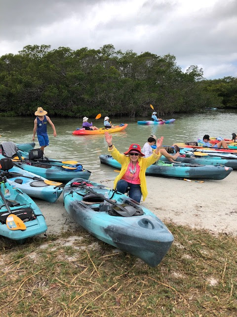
 I first learned about kayaking through mangrove tunnels five years ago, when I was visiting Sarasota, Florida, for the first time. From that moment on, I put it on my "to do" list!


 This wide expanse of open water is one reason the mangrove tunnels exist today. It used to be a small lake, separated from the sea water in Sarasota Bay. The stagnant water of the lake promoted the growth of mosquito populations, which carry malaria and other harmful diseases. Therefore, decades ago---before much was known about its hazards---a chemical substance was spread over the lake to kill the mosquitoes. It not only killed the mosquitoes, but all the flora and fauna associated with the lake habitat. The officials came up with the solution of making small canals, connecting the sea with the lake. Over time, this allowed the damaged lake water to flow out into the open ocean. As the habitat improved, mangrove trees begin to grow around the tunnels, eventually forming a canopy over them. Folks enjoyed exploring the green tunnel habitats, and "voila", a tourism attraction was created. The tunnels are very shallow, so the advent of lightweight, plastic-like kayaks that require just a few inches of depth in order to proceed, was also a factor in its popularity. Then, the increasing numbers of folks starting to do standup paddle boarding (SUP), brought another group of outdoor enthusiasts to the location.
 "
"


.jpg)


