Fifty years ago, I embarked on an expedition, unlike any I had ever been on before, or would be again. It was called childbirth, and it made me the mother of an 8 pound, 8 ounce little boy. Although I had taken a course in college called "Child Development", I had no real life experience in infant/child care, as I had NEVER done any baby sitting. However, a few weeks after my son (I will call him G for this blog post) was born, a Registered Nurse came to our home to visit, and give me some pointers. She was the director of the nursery where I attended church, and she was also the wife of the physician who had delivered my son. However, after my son was older, and I introduced him to this man as the physician who delivered him, the doctor humbly said, "All I did was catch him!" I felt comfortable taking my son to the church nursery on Sundays, knowing the Registered Nurse would be there to supervise his care. Also, there were several ladies in the church nursery who had worked there for decades, and were experts at taking care of babies. I knew I could learn a lot from them, so I started volunteering in the church nursery on Sunday mornings, and it was very beneficial! I am very thankful for the opportunity I had to take G to church, and was overjoyed when he made the decision to accept the fact that Jesus had taken the penalty for his sins, by being crucified on the cross. His decision is assurance that we both will be reunited in heaven, after we die.
I have enjoyed celebrating my son's birthday, from the very first one (shown in circular photo of collage), and on through the years, as he left home, and was living in locations around the country. Whenever possible, I like to continue the tradition of using the red, tradition-laden, "YOU ARE SPECIAL TODAY" plate, on such occasions! These photos bring to mind a favorite verse I like to associate with a photograph of loved ones. It says, "I thank my God upon every remembrance of you." Philippians 1:3
I remember a "travel birthday celebration", when my husband and I picked G up at college, and we took a flight to Nevada, to celebrate in Las Vegas. We went to see the famous show, Cirque du Soleil at the Mirage, and stopped to have a photo made at the Harley Davidson Cafe.
I actually have a thank you note from my son, that I kept and framed, because it was the only time I have a letter from him, written in cursive!
This blog entry, is about a trip I made from Arkansas, to California, to celebrate my son's 50th birthday. I flew out of Tulsa, Oklahoma, at sunrise, and started "puddle jumping" across the country, with stops in Denver, Colorado, and San Francisco, California.
My son picked me up at the Redding airport, and we headed to Costco, to purchase the necessary supplies needed for a weekend of hosting several other family members, who were also coming to celebrate his birthday. I was quite hungry, so the first thing we did in Costco, was try out their famous bargain of a footlong hot dog, and beverage, for only $1.50!
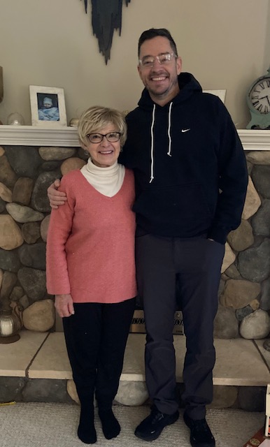
My son (G), and his wife (S) were eager to show me the gift S had given G for his birthday, a Pelaton treadmill! They already had the Pelaton bicycle, which I had tried out on a previous visit.
I use an "old fashioned" treadmill regularly, so I was eager to try out the Pelaton, as was my son's mother in law (J):
The four of us went on a day trip to explore northwest California, and stopped in the tiny town of Etna, to have lunch at a popular spot there, called Denny Bar (www.dennybarcompany.com)
G chose this area to explore because he wanted to see what the landscape looked like, in the area where dams across the Klamath River had been dismantled. The photo below shows the large, empty reservoir, that used to be full of water that was impounded by the dam. The body of water you can see flowing through the bottom of the photo is the now-free-flowing, Klamath River.
Once back at their home, it was time for the always enjoyable mother-son "Show and Tell" update! G showed me the ship models he as been painting---seems like an appropriate hobby, considering his last name!
I also saw the repair job he was completing on a small cedar chest my father had made.
It was fun walking on their property with his wife (S), her daughter (K), and grandson (C). And, or course, their dog, "Indiana Jones", enjoyed sniffing around the woods!
Thankfully, there was not a big snowstorm that impaired my travel, but there WAS enough leftover snow, to show C how to make a snowball, and instigate a snowball fight!
This photo shows S, and her mom (J), teaching C about their container garden, which actually had some green things growing in February!
Since I like lettuce, C and I posed for a "Lettuce entertain you" photo!
Continuing the outdoor activities, C played in the dirt with his construction toys, then "Pappy G" let him sit on his lap for a photo on the tractor! The "Pappy G" nickname is a nod to what G called his maternal grandfather---Pappy Joe.
Photo below shows C and his father, D, trying out a "Strider" for the first time. This device uses the principle of "subtraction", to facilitate a desired outcome. The goal is to get a youngster comfortable, just walking, with a two-wheeler between their legs, before they possibly become discouraged by trying to learn to pedal a two-wheeler. Notice there are no pedals to master---the power of subtraction! The publisher of the theory about the "benefits of subtraction", speculated our culture could have better outcomes in many areas, if we gave more consideration to "subtraction"!
Yippee! A photo of my son on his fiftieth birthday, with the YOU ARE SPECIAL PLATE, while he enjoys his morning coffee, in a custom-made ceramic mug.
No birthday celebration is complete without a cake, which K and D "imported" from Oregon.
We all got a laugh, whenever C swooped in to blow out the candles before Pappy G!
So now, my collage of birthday celebrations for G, spans from the age of one year to fifty years!
That little boy that was 19 inches long when he was born, is now LOTS taller than the mother who birthed him!
This wooden high chair has quite a history in G's family, and continues to be a good photo prop!
I was very thankful that D got the set up arranged, so we could get a group photo outside, during the short period of my visit, when there was not precipitation falling from the sky! That beautiful red beard belongs to S's son, who also has a "C" name. Could there be Vikings in his ancestry??
One of our indoor activities during my visit, was making bread, and S shows C a loaf just out of the oven, that is almost as big as he is!
I was very impressed with this bread machine, because it accidentally vibrated itself off the kitchen counter, and sustained a dent, and broken-off lid. But amazingly, with the help of a bungee cord to fasten down the lid, it continued to work! The incident gave a whole new meaning to the phrase, "Breaking bread together!"
One of the places everyone wanted to have a breakfast item from, was the Seven Suns coffee shop. It was President's Weekend, meaning the town was overflowing with tourists, so we placed our orders by phone, then D and I went to pick up the yummy breakfast burritos. Notice the quarried volcanic stone, and river rock, used to make this historic facade.
The rain continued, so we treated G to an indoor game of bowling for his birthday, in the town with the worrisome sounding name of "Weed". G's father once bowled a perfect 300 game in a tournament in Springfield, Missouri, but that was not to be the case for G on his birthday!
G took a video, of C's mom and dad showing him how to use the "dinosaur" slide, to give the bowling ball the necessary speed it would need to make it, to the end of the lane.
Another table game we played was called "Wingspan". It will teach you facts about birds and their habitat that can be fascinating, but overwhelming!

- One reason my son moved out west when he finished medical school, was for the rock climbing opportunities. He has built an indoor practice climbing wall everywhere he has lived, since he left his childhood home, so it is not surprising that he has now built one at his newest location! (At one point, he even invested in building a commercial climbing wall, as a part of a venture into retail business)
His Pappy Joe also enjoyed building things (as well as fishing!), and is shown in this photo with youngster G, with a fish Pappy Joe caught, and the house he built in the 1940's. That style of stone work is common in the Ozarks, and is called "giraffe style".
Although it is a different kind of "fish", the photo below shows Pappy G and C, as they practice "fishing"!
There was a pool table in the downstairs recreation room of G's childhood home, so it is only fitting that there is also a pool table in his present home! It was fun playing the game with G, S, and J.
I think I could have been a better player all those years ago, if I had seen one of these "training balls", like G has with his present table!
After a fantastic visit with family, G and S drove me to the airport in Redding, where I boarded a plane going eastward, with the first stop being in San Francisco. I have a much greater appreciation for the famous Golden Gate Bridge leading to that city, after I walked across it, and back, as part of a Road Scholar (www.roadscholar.org) program I attended. That same Road Scholar program facilitated hiking many of the areas of Marin County, shown in the photo below, that I took from my airplane window. (See the photos I posted about that adventure, in the archives of this blog. It is entitled "Hiking the Golden Gate Bridge Expedition!", and has a date of June 15, 2019.)
The next stop on my journey eastward was the iconic Denver International Airport. It is a dramatic sight at any time of the day, but I found it to be especially photogenic from my airplane window at nighttime.

Speaking of nighttime, it was around midnight when my plane finally landed at the Tulsa, Oklahoma airport. I retrieved my car from the airport covered parking lot, and made the short drive to the adjacent Hilton Hotel. A night of restful sleep enabled me to complete a "bucket list" item, that has been in my mind, ever since I heard about the completion of the Tulsa Riverwalk Trail. A while back I had hoped to walk it on a day I was in Tulsa, but the highway I needed to use to get to the access of it, was closed for circumstances beyond my control. Hence, the delay! Fortunately, this time, the highway was open, my GPS took me straight to the parking lot, the skies were clear with no rain/snow, and the temperature was perfect for walking in the outdoors! The paved trail is used by both pedestrians and bicyclists, and follows the meandering of the Arkansas River, through the Tulsa area. You can get more details at www.visittulsa.com

The photo below shows my shadow, waving farewell, and saying a prayer of gratitude, that I was able to be with my son on his fiftieth birthday! This "Half-Century Expedition" gave me MILES OF SMILES! Tricia


.jpg)
.jpg)


.jpg)

.jpg)


 Ozark Isle started out as a Corp of Engineers campground within Bull Shoals Lake in northern Arkansas. It was originally the top of a mountain that was made somewhat inaccessible, when it became surrounded by water, due to the dam across the White River, that led to the formation of Bull Shoals Lake. For this reason, a "causeway" was constructed by the Corp of Engineers that would connect the isolated island, the short distance that would link it to the "mainland".


.jpg)


