Saturday, May 28, 2022

ANTELOPE CANYON EXPEDITION!

This blog is for someone planning a trip to Antelope Canyon, near Page, Arizona, to show them the "nittygritty" of how it works.  The first thing you need to do (after you have decided on the calendar days that would work for you) is book your tour with one of the Navajo-owned companies, that take visitors through the canyon.  You can go to the website for visiting Page, Arizona (www.pagearizona.com) to see the various tour companies in that area.  I used Antelope Canyon Tours (www.antelopecanyon.com), and their office location in Page, Arizona (which is also where you board the vehicles that take you to the canyon) is shown in photo below:


After you have checked in with the office, you will be assigned a tour group truck number.  The driver of that truck will call out for his passengers, and direct them to the specially designed, open air pickup trucks.  The information on the website makes it clear that the tour is NOT wheel-chair accessible, and that participants need to be in good enough physical condition to walk, climb the bus ladder, and climb stairs over a small mountain, at the end of the tour.  There is a video on their website of a person with a "GO-PRO" style camera completing the stair climbing and walking trail the participant is required to navigate, so the prospective visitor can assess their ability to safely meet the criteria.  When I was there in May, 2022, the website also had repeated alerts, saying that face masks were required in the office, on the vehicle ride, and during the entire tour (including having your photo taken while inside the canyon).  One needs to be able to climb the small ladder shown in this photo, to get into the back of the truck:


The  truck travels city streets of Page for a few miles, and there are seatbelts on the bench-style seats, that riders must wear. (NOTE:  The seat belts are designed for two people to be enclosed within the same belt, so expect to get cozy with whomever you might end up sitting by!)

The truck then turns onto the Navajo Nation property, that lists the location of LeChee, Arizona (about 20 minutes outside Page).  The "road" is actually a dried-up riverbed, which became very dusty with the tour truck traffic, so that I was glad I had a mask on, to keep out the desert dust!  The riverbed leads directly to the entrance of Antelope Canyon, which would make sense, since it is raging flows of water down this river bed during monsoon-season floods, that chiseled out the unique formations within the canyon walls. 
Notice  the white trucks in the parking lot are pointed forward, towards the "mountain", as the groups start to enter the canyon.  When the tour was over, the trucks had all been turned around to point in the opposite direction.  This was a nice courtesy for both our current tour truck driver and us guests.  That is because all those trucks turning around in this "dust bowl" stirs up a thick cloud of dust, that had time to settle back down, by the end of our tour.
 
Photo of white trucks that had been turned around to point towards the exit direction, after our tour was over:


Antelope Canyon is a type of "slot canyon" that occurs in various locations throughout the Southwest.  Most explorers have heard the story about people drowning in slot canyons, when they were quickly and unexpectedly, overtaken by raging flood waters.  The sign below is at the entrance to the canyon, and is a reminder that tourists drowned here a few years back during a flash flood (even though there was no rain occurring in the near-by area, at the time they started their tour).  Since that incident, improved weather tracking and warning systems have enabled officials to stop tours, well before the threat of a flash flood is imminent.

The Navajo Nation tribal rules were still requiring a mask at the time of my visit, even though they were no longer being required in Page, Arizona (which is outside the Navajo Nation boundaries).  Our guide told us this was because "the Navajo people were hit very hard by COVID19", and extraordinary measures were being continued to reduce the threat of illness.  Like many other tourist attractions, these tours were closed down completely at the height of the pandemic, and have had a gradual, "staged" return to full capacity.  Our guide told us the company had just recently gone to 75% capacity for guests, after successfully navigating the business at 50% for a period of time.  According to Wikipedia, by April 20, 2020, the Navajo Nation had the third-highest infection rate in the United States, after New York and New Jersey.  As of May 18, 2020, the Navajo Nation surpassed New York as the most affected U.S. region per capita.  It is very understandable why they are being extremely cautious!
As we entered the opening of the slot canyon, one could feel the temperature difference, with it being much cooler within the shade, provided by the tall walls of sandstone.
My son had taken the tour a while back and alerted me to the possibility of the guide showing guests how to adjust their smart phone camera, to get the best results. So I was the first one to hand him my phone, when he had suggestions on how best to photograph, what we were about to see.  He recommended the guests adjust their setting to "VIVID", instead of normal, and NO FLASH.  For guests that did not know how to work their smart phone settings, he was very patient in assisting them.  Especially before digital cameras, photography within the canyon was uniquely challenging, because of the wide exposure range, made by light reflecting off the canyon walls.  For several years, there was a specialized "photographer tour" of the Upper Antelope Canyon, where participants needed to have a tripod and camera.  In fact, the first time I remember seeing a photo of Antelope Canyon, was by a photographer I met on an art studio tour in Sedona, Arizona, several years ago.  She told me that she had participated in the special photo tour, and that openings for any kind of tour (photo or otherwise) were a hard-to-come-by prize, because of the limited size and number of tours that the Navajo Nation permits.  These specialized photography tours had been discontinued at the end of 2019, even before the pandemic hit.  I believe it was a definite blessing from God (a "God-Wink", some might call it), that I HAPPENED to be in the group whose guide just HAPPENED to have been one of those talented photographers who had led the specialized tours!  In fact, he has won awards for his landscape photography, and used to be allowed to do wedding photography inside Antelope Canyon!

Expect to spend a lot of time looking upward, as you go through, because with every step you take, the formations above and around you change shapes and colors.


I took the photo below, looking straight up, dozens of feet above my head.  The object straddling the ceiling opening, is the trunk of a tree that was washed into the canyon, during one of the flash floods. (You can see the tree trunk's "bushy" branches on the right end of the opening). 
The wave-looking surfaces of the canyon were formed by the erosion of Navajo Sandstone due to flash-flooding and sub-aerial features (sub-aerial means "under the air", as opposed to "under the water")  During monsoon season, rainwater runs into the extensive basin above the slot canyon sections, picking up speed and sand as it rushes into the narrow passageways.  Over time the passageways erode away, deepening the corridors and smoothing hard edges to form characteristic "flowing" shapes. 
All of my photos were taken in Upper Antelope Canyon, which has a ground-level entryway, and a flat interior passage way for guests; hence, it is more popular with guests than a different option, called the Lower Antelope Canyon tour.  For the lower canyon, there are ladders to descend/ascend, to get access to the interior. 

A person could go through Antelope Canyon hundreds of times, and get different views each time, depending on how the light from above is reflecting on the surfaces.  The photo below shows how in some places the passageway narrows so that guests need to pass through single file.
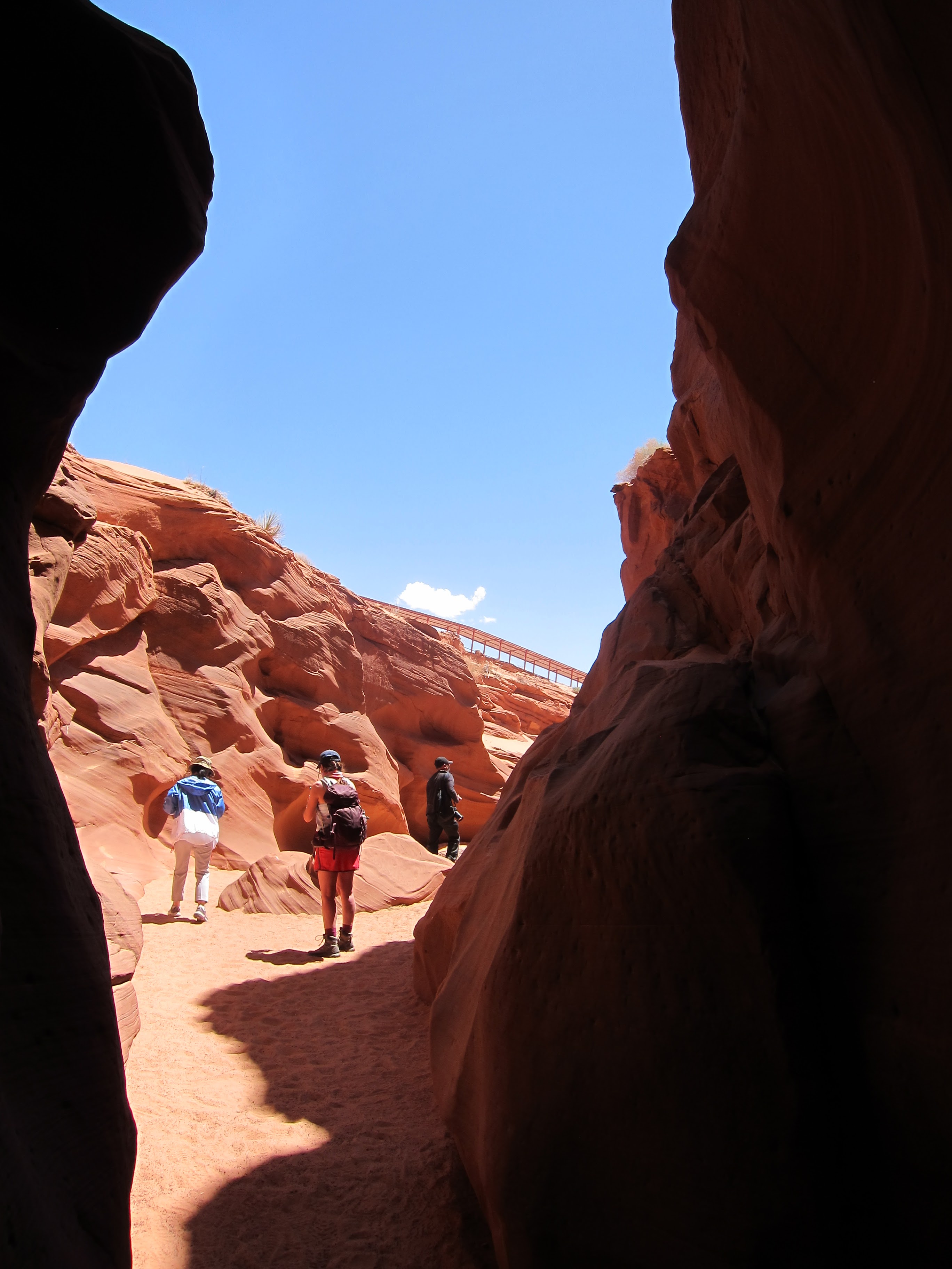
The photo below shows what the eye sees as one exits the inside of the slot canyon.  The curving line above the hill on the horizon, is the sunroof of the metal walkway that one must ascend, to get back to their tour vehicle, on the other side of the mountain.
Just a short distance from the end of the slot canyon, metal stairs have been installed that the guest must climb to get over this hill that is above and beside the slot canyon.

Once we ascended the stairs, the upward ramp was covered to provide sun protection:
This is what the slot canyon looks like from above:

This photo shows the full length of shaded ramp:

The sign encourages using the hand rails, and knowing this, our guide gave us all a generous squirt of hand sanitizer when we reached the bottom of the stairs.

The photo below shows my tour guide, Mr. Rick B., who was FANTASTIC!  The fact that he had heard of the Arkansas Razorbacks was also a big plus!  When I asked how he was so quick to associate my Arkansas accent with the Razorbacks, he said he had been on the Kansas JayHawks track team in college, and had competed against the Razorbacks!


Our guide had done professional portrait photography in the canyon in the past, and knew the best locations to place his guests, to provide the lighting needed for the picture to turn out:


There was one point on the tour that the guide knew the light formed a heart shape, so he took each guest's photo, within that heart shaped light.  He had a helper shine a muted flashlight on the subjects face, so that it could be seen.  Notice my lower torso is indistinguishable because of the way the light is coming through the "ceiling" opening of the canyon.  I theorized that our very experienced guide had taken photos of his guests without the "muted" flashlight used to highlight their face, and was not as pleased with the results, as when the flashlight provided just enough light to show the face.

 The heart-shaped "light painting"  on the wall is made possible, because of the heart shaped opening at the top of the canyon at this location.  You can see that opening in the photo below:


If you get to the canyon at the right time of year (between May and October), and the right time of day (around noon), and the right weather conditions (clear skies), there is a strong beam of light that shines straight down through the opening; and, once again, I just HAPPENED to book the very last noon-time opening, available for this "HAPPENING"!  The guide wanted to take each of our photos beside that beam, asking us not to stand directly under the beam:

 
The next photo shows a girl in the foreground, with a path of light leading to her, that emanates from the beam of light that is shining on the dust.  Seeing the way the column of light illuminated the dust in the air inside the canyon is providing the visual aid for one of my First Place 4 Health (www.FirstPlace4Health.com) from Psalm 103:14 that says,"For He knows how we are formed, He remembers that we are dust."


I have been on dozens of group tours, but I have NEVER been on a group tour where the guide was so obviously enjoying taking photos of his guests at different locations!  And it was not just me---every individual, couple, or family who wanted their photo taken could hand the guide their phone, and he snapped a postcard-worthy photo of them!

Besides the heart shape in the ceiling, many guests see the outline of a tall vertical candle, at the location shown in the photo below:


Some of the guests were calling this line-up of shapes on the right side of the photo, the "Mt. Rushmore" of Antelope Canyon.
What anthropomorphic shapes do YOU see in the photo below?
The photo below shows the flat, sandy passageway that guests walk on throughout the tour:
If you wear a big hat, like the one shown in the photo below, make sure it is secure on your head, because you spend a big part of the tour with your head extended backward and upward, as far as it will go, so you can take in the incredible beauty that is above your eye-level!
One of the fascinating aspects of our tour, was when the guide took a small shovel-full of sand, and created a "sand waterfall" over the edge of one of the outcroppings:


When our guide showed us the location where many guests see the profile of "The Holy Man" (Jesus) formed in the earthen walls, I realized this could be the visual aid I needed to help me learn one of my First Place 4 Health ( www.FirstPlace4Health.com ) memory verses.  It says, "But I have raised you up, for this very purpose, that I might show you my power and that my name might be proclaimed in all the earth."  Here I was, inside the earth, and Jesus's name had just been proclaimed, inside this very spot, of all the earth!
The tour of Antelope Canyon is something I have been wanting to experience for YEARS, and it was--- literally---something I went to sleep thinking about, the night before my tour!  The Wyndham location (www.wyndhamhotels.com) where I stayed in Page, Arizona, had a giant-sized photograph of the canyon above my bed, assuring "Mr. Sandman" would send me a (sandstone canyon) dream!  I can say with certainty, this tour of Antelope Canyon gave me "MILES OF SANDSTONE SMILES"!  Tricia 


Monday, May 2, 2022

SAN RAFAEL SWELL EXPEDITION!

The San Rafael Swell can be thought of as a "swell" or "uplifted bump" on the surface of the earth.  The exhibit below helps a visitor  see the unusual landscape in a three dimensional model:
Over time, the effects of wind, water, volcanic activity, floods, and temperature extremes,  caused the "swell" we look at today, to be full of structures with varying heights, shapes, and composition.
On numerous trips through Utah, I have driven through the section of Interstate 70 that bisects the San Rafael Swell.  The red line in the three dimensional model represents Interstate 70.
The photo below shows the divided highway snaking through the jagged cliffs of the Spotted Wolf Canyon, onto the desert floor.  The construction of the Utah portion of I-70 is listed as one of the engineering marvels of the Interstate Highway System.  As a two-lane route, Utah's I-70 was dedicated in 1970; but, the divided highway we use today was not fully completed until 1990.  Most of the area designated as a part of the San Rafael Swell is within Emery County in Utah, and you can access the Emery County Travel Bureau at www.sanrafaelcountry.com

When I visited this overlook in July, 2021, I saw people exploring on the cliffs below the parking lot, and I wanted to do the same!  However, I decided it was not wise to take off down the mountainside alone.
My son is used to rock climbing, so I waited to do my exploring until he was with me!
There are placards at the various I-70 overlooks, that tell stories about the history of this unusual area:
The Head of Sinbad is one of the best preserved ancient pieces of rock art in the world.  It sits unassumingly on a wall a dozen feet off the ground, in the desert wasteland of the northern San Rafael Swell.  Thousands of cars pass nearby every day, but most people do not know these examples of ancient art, lie just a few miles north of the paved highway.   The whole area around the anthropomorphic pictographs is named Head of Sinbad. 
Ghost Rock is a pinnacle along I-70 within the San Rafael Swell.  The legend says a cowboy on a foggy morning saw the top of the pinnacle protruding from a bed of fog, and thinking it appeared ghostly, dubbed it "Ghost Rock".
The name "San Rafael" relates to Saint Raphael, who is considered the patron saint of healing.  He is considered the special angel of apothecaries---meaning nurses, pharmacists, physicians, and others who minister to the sick.  Since both my son and I chose careers in healthcare, we could be included in that group!  Here is a photo a kind tourist took of us, as we started our trek across the rock outcropping:
I was thankful to be making a return visit to this area, so my son could evaluate the feasibility of various routes I wanted to explore.  In this photo, he is studying the rock composition, to evaluate its suitability for various types of rock climbing:
Although I am not a rock climber, I like to pretend!
The rocks here are full of cracks, that beg to be photographed!

Some of the cracks can even serve as a "chair" of sorts!
No visit to a place this amazing, is complete without a gesture of gratitude with my arms uplifted!
There are numerous layers to the landscape that make up the San Rafael Swell:
Just as this ceiling banner covers all the different rock layers of the San Rafael Swell model that is below it, so God's love covers all the different parts of our planet Earth.   And, it is God's love that needs to bind together all the various attributes (virtues) that Christians strive for.  I am using this concept as the visual aid for one of my First Place 4 Health (www.FirstPlace4Health.com) memory verses that says, "And over all these virtues, put on love, which binds them all together in perfect unity."  Colossians 3:14
Besides providing a visual aid for my memory verse, this trip was a wonderful time to "bind together" with my son (aka "family bonding time"), as we enjoyed the beauty of God's creation!
That is why a visit to Utah's San Rafael Swell, gave me "MILES OF SMILES"!!

Friday, April 1, 2022

FINLEY FARMS EXPEDITION!

There is a "new attraction" in Ozark, Missouri, along the Finley River, that is based on a very "old attraction" along the Finley River, that has been around since 1833!  It is called The Ozark Mill, and is surrounded by an urban farm, called Finley Farms.  There are no Las Vegas-style flashing neon lights indicating its location, just these massive vintage storage tanks, that mark its entrance.

 One of the first things you see as you drive onto the property,  is the shed called the Farmers Market, and it is scheduled to open May 5. 

The inside appearance of the farmers market  resembles numerous other structures in the Ozarks,  that have the look of weathered oak lumber.  The farmers market will operate each Thursday, May through September.  Flowers, plants and produce from the farm will be sold at the farmers market, as the growing season progresses.

Adjacent to the Farmers Market building is the Workshop.  I read this used to be a garage. 
There is a coffee bar inside the workshop that sells a variety of treats:

The tables inside the workshop with the live plants down the center, are a reminder to say that they offer classes in how to start plants from seeds and cuttings, inside this workshop space.  They carry everything you need to "plant your heart out"!  We saw tools and terracotta, starter seed kits, seed markers, and gardening books galore!

One whole side of the Workshop has overhead-garage type doors that open up to enjoy the fresh air whenever weather permits:

There is an outdoor patio adjacent to the Workshop, that also has a live plant area:

In addition, the outdoor patio also has a fire pit and stage area:


When you see the numerous rows of crops spread out across the acreage, along with the green houses, you will understand why the word "farm" is included in their name!!

Picnic tables and playground equipment are also adjacent to the workshop.

After visiting the workshop, our group strolled over to the restaurant location, so we could be there when they opened up at 11 am.  This gave us the opportunity to get an overall view of the restored mill from the front, and envision what a huge endeavor it was to move such a large structure!  Johnny Morris has owned the Ozark Mill for more than 25 years, but did not develop it because multiple floods had washed away the underside of the mill's foundation.  However, after decades of deliberation, he hired a construction company that picked up the entire 30,000 square foot building and delicately moved it to the parking lot.  The washed-out foundation was replaced with a structurally sound basement, and the building was moved back to the river, and placed on top of the new foundation. 

Once the doors opened, and we checked in with the hostess, we used the time they were getting our table ready, to check out the gift shop, and other parts of the building: I took the photo below of the main dining area, before any guests had been seated.  Since one entire wall is windows, all the diners can look out over the Finley River, and see the waterfall below the old mill pond:
The location of the Ozark Mill restaurant, is in an area near where the historic Riverside Inn used to be.  The Riverside Inn was finally torn down, after repeatedly being flooded.  Just before it was torn down, I was able to go inside and see all the wall murals painted by the original builder, Howard Garrison.    
Unlike many waterpowered mills that used a vertical waterwheel, the Ozark Mill was powered by a horizontal waterwheel.  Regarding the mill renovation project, Johnny Morris is quoted as saying,  "This is a very special project to me and my family.  We have deep family ties to this town, the rivers of this area and to the milling industry.  My grandfather Willie was a miller in Willard  Many years ago, my parents lived on the Finley River millpond in the early 1940's, and my family was proud to call Ozark home for a while."

Traditionally, mills were the place for the folks who lived in the area, to gather and visit, while their grain was milled into flour or cornmeal, back in the olden days.  The spacious retail area of the mill will allow this tradition to continue, as there are game tables, wall dart boards, and lounging chairs spread across the space. 
In today's high tech world, the visiting that goes on within the mill can be shared with your friends across the planet, as their is free Wi-Fi throughout the building.


The staff of the mill restaurant was friendly and helpful, even taking a photo of our group together on the bench in the waiting area.  Note the date on the boards reads 1833, and that relates to the fact that there has been a mill at this location since 1833!  If only these walls could talk---imagine the tall tales they would tell!


Our group wanted to get to the restaurant as soon as they opened, so we could all have a table together.  When I phoned about making a group reservation, the operator told me they do not take reservations, but if our group got there when they opened at ll am, they could get quickly get a table ready for a large group such as ours.  They seated us in a prime location, with a view of the river and millpond out the windows. 
Outdoor seating options are also available for dining:
 
 
About an hour after the restaurant opened, every single table on this outdoor deck was filled with diners enjoying a sunny day in the Ozarks!
The photo below shows the newly-restored basement level of the mill property.  It is being made into a "speakeasy".  The speakeasy will be called the Garrison, named for Howard Garrison, of the old Riverside Inn.  This relates to the legends that say, during Prohibition, Garrison had several run-ins with the law, for offering bootleg liquor and illegal gambling. 

Once we finished lunch, we strolled across this historic bridge, which used to be adjacent to the Riverside Inn.  Locals called it the Riverside Bridge. 
The bridge was originally a railroad bridge built in 1909.  It carried the Frisco Railroad's Chadwick Flyer passenger/freight train across the Finley River. 
When the bridge was severely damaged in the flood of 2015, it was scheduled for demolition.  Instead, Morris bought the old bridge and had it moved to Finley Farms next to the mill. 

Some tourists who were also visiting the property for the first time, agreed to take a group photo of us:
The bridge is open for visitors to use, unless there it has been rented for a private event.  The bridge leads to a spacious outdoor venue across the river from the Ozark Mill Restaurant.
That area has an open air chapel, which is available for weddings and other festive celebrations, and has a great view of the river:
The rafters, trusses, and lofty ceiling, have the aged look of an old barn made from oak, that one might see in the Ozarks.  Even though our group arrived at the chapel via walking the bridge across the river, there is also access to the chapel via automobile, using the adjacent street.
There is a gothic-style metal archway, that provides the perfect frame, for a view of the millpond waterfall and Finley River.  I can only imagine how this view would be enhanced, when that arch is covered in colorful, fresh flowers, for a wedding celebration!

I am using this visit to Finley Farms as the visual aid to help me learn one of my First Place 4 Health (www.FirstPlace4Health.com) memory verses, because the verse starts with three words that seem to be the mantra of conservationist, Johnny Morris---the words are "Let us fix...".  For example, Let us fix  a small fishing lures area of a Brown Derby store,  into the nation's largest outdoor supplier, called Brass Pro Shop; Let us fix an old stone house, into Big Cedar Lodge; Let us fix a rugged undeveloped hillside, into Dogwood Canyon;  Let us fix a burned down golf course restaurant, into Top of the Rock five-star dining destination;  Let us fix a vacant glass pyramid on the Mississippi River, into a Bass Pro Shop with a hotel and bowling alley; Let us fix an old Ozark grain mill and historic bridge, into a restaurant,  and educational farm on the Finley River; Let us fix an unexpected sinkhole developing on a golf course, into a major tourist attraction; Let us fix an abandoned wildlife museum in Springfield, Missouri (which was vacant from 2007-2017) to the nation's top new attraction for the year it opened, (called "Wonders of Wildlife"), and his current project---Let us fix an  abandoned amusement park in Newton County, Arkansas, (Dogpatch, USA),  into a major rural tourist destination, for travelers wanting to experience the beauty of the Ozarks.  LET US FIX, indeed!

The Bible verse I speak of, is from Hebrews 12:2 and says, "Let us fix our eyes on Jesus, the author and perfecter of our faith, who for the joy set before him endured the cross, scorning its shame, and sat down at the right hand of the throne of God."  

I want to extend a big THANK YOU to Johnny Morris and team, for the conservation and preservation work, they have done, and are doing, in the Ozark Mountains of Missouri and Arkansas.  Your efforts and your "Let us fix" attitude, are appreciated!

If you would like to plan your trip to the lovely Finley Farms destination, you can visit their website at www.FinleyFarmsMO.com  The expedition I had to Finley Farms,  with a great group of friends, gave me "MILES OF SMILES"!!  Tricia