
I recently had the blessing of spending a week with my son and his wife in the area where they live in Northern California. They took me to explore several trails in their part of the Pacific Northwest, and this blog post is about the section of the Pacific Crest Trail we hiked, near the small town of Dunsmuir, California.

My
son took this photo of me as we started out the hike, with the trail sign "PCT" pointing the way up the mountain, where this "dog leg" or "spur" trail would connect with the PCT---Pacific Crest Trail.

I convinced
my son and his wife to pause, so I could get a picture of the sign indicating we were in the Castle Crags Wilderness section of the Shasta-Trinity National Forest.

And naturally, I wanted a photo of all three of us "selfie" style, which my son obliged with his long arms!

The spur trail leading up to the main Pacific Crest Trail was very steep and rocky, which is understandable since the PCT in this area traverses mostly the upper heights of the mountains, rather than the river valleys. It closely aligns with the highest portion of the Sierra Nevada and Cascade Mountain Ranges, which lie 100-150 miles inland from the Pacific Ocean. Another reason for the roughness is that the PCT is an equestrian, as well as pedestrian, long-distance hiking trail.

When the spur trail connected with the Pacific Crest Trail, this sign confirmed that we were now officially on the PCT. We hiked to the left, towards the Trinity Divide. Detailed maps of the PCT are available at
www.pcta.org .

Several years ago, I was able to do some hiking with my husband on the Pacific Crest Trail at its lowest elevation, The Cascade Locks, on the Washington/Oregon border. That was just a few years after the PCT was officially completed in 1993. (It was first designated as a National Scenic Trail in 1968, when President Lyndon Johnson signed the "National Trails System Act". ) I purchased a Pacific Crest Trail medallion for my hiking stick in the 1990's, so I was delighted to have the opportunity to hike a section of the PCT in California, because that meant my hiking boots had at least "touched down" on the PCT in all three states it goes through in the USA---California, Oregon, and Washington.

We started our hike about mid-morning, so much of the walking was in the shade, and the June temperatures in the mountains were very pleasant. As this photo indicates, I was usually several paces behind Grover and Stacy, which I attributed to being a "flatlander", who had not yet adjusted to hiking at the higher elevations!

As we approached the summit, where the base of the famous stone outcropping known as Castle Crags is located, there was more sun exposure.

This photo
shows the jagged formations of Castle Crags on the distant horizon. This is one of 25 National Forests that the PCT passes through. In addition, is passes through 7 National Parks. In fact, its midpoint is near Chester, California, in the Lassen National Park area. ( We had hoped to hike to the top of Lassen Peak later on this trip, but its access roads were closed due to excessive snow).

Stacy spotted a lizard along
the trail, and fortunately, that was the only reptile we encountered. I say fortunately, because I tend to scream when I see a snake on the trail, regardless of whether or not it is poisonous!

When I was reading about the trail on the Internet before we went, there was a warning to be on the lookout for poison oak, which the literature said was prevalent. The warning was accurate, as the bright green, very lush-looking, low ground cover lined some sections of the path.

I started to stick my hiking boot into it, to give some scale for a photograph, but my son warned me that the oils from the leaves of poison oak can get onto your hiking boots. Then the next time your hands touch those hiking boots, the oil is transferred to your hands. Of course, this can cause you to expose other parts of your body, especially eyes and face, to the noxious chemical .

Grover
and Stacy each stepped to the side to let a pair of through-hikers go past us, with their heavy back packs making them easily identifiable as someone not out for a short stroll in the woods. The girl and guy were the only other hikers we encountered the whole time we were out. In other words, it was not a crowded trail! However, awareness of the Pacific Crest Trail has been elevated after the publication of the book
Wild, by Cheryl Strayed. The book inspired the movie by the same name, starring Reese Witherspoon.

We were not trying reach the Trinity Divide on this hike, rather a picturesque location called Burstarse Creek. I say "picturesque", because it is not every day that you can get a photo of what appears to be a tree "biting down" on a wooden sign! It was about 3.2 miles to Burstarse Creek, so our total mileage for the day was about 6.5 miles.

The creek was not flowing heavily, but there were pools of water that could have served as a source for through hikers, needing to filter some drinking water for their trek.

The moss-covered rocks are a clue that this area regularly receives run-off from higher elevations, brought on by rain or snow-melt.

There was spotty cell phone coverage where we hiked, but if you could use the Internet, you would learn that the Pacific Crest Trail is 2,659 miles long, and ranges from just above sea level at the Oregon - Washington border, to 13,153 feet at Forester Pass in the Sierra Nevada mountain range.

There were a few spots where water trickled over the boulders, and made a pleasing waterfall sound. This is the spot where I stopped to rest and have my lunch.

Grover and Stacy continued up the rock race of the mountain, with Grover assuring his wife that the summit was just a short distance away, and they would be back "in a wink". (I took so many photos of my son during my week visiting him, that he told me he felt like he was being followed by the "
mamarazzi", rather that the "paparazzi"!)

I handed over my camera to my son, and asked him to take some photos of the trip up, so I could see what I missed. Judging from the steepness of this photo, I think I made a wise decision in staying behind!

After climbing a distance on the rock face, they came to a location where Grover could get a photo of water cascading over the top of Castle Crags.

There was still snow on area mountain tops, so part of this waterfall is probably made up of snow melt.

I became aware of this area by an email I received from my son the first month he moved there, several years ago. It said, "Totally stoked! Climbed Castle Crags today!" To show you how uninformed I was, I had to google the slang meaning of "stoked", as well as what in the world was "Castle Crags"??!!

Most of the jagged peaks that give the mountain top the name "Castle Crags", have individual names, and many of them are used by recreational rock-climbing enthusiasts.
I am very fortunate to have been able to hike the Castle Crags area of the Pacific Crest Trail with a local author who has published a definitive book on the history and geology of this area:
A photo of the author of the book is shown below, standing on a crag outcropping, and I am thankful to say "he is my beloved son, in whom I am well pleased"! If that sounds like a familiar phrase, it is my version of Matthew 3:17 that says, "This is my beloved Son, in whom I am well pleased."
I was glad my son had pre-hiked this trail, which he had done while doing the "footwork research" for the book he published, called
Mt. Shasta Area Rock Climbing. It is available from Amazon.com (
www.Amazon.com ), as well as the local Mt. Shasta Chamber of Commerce office, as shown in the photo below:

As I was writing this blog, I was reminded of a Road Scholar (
www.roadscholar.org ) hiking program I attended in the California Redwoods. One of the advertised features of that particular program, was the opportunity to hike with the author of the definitive hiking guide book, for the trails in the Redwoods. Now I was getting to hike in the Castle Crags Wilderness with the author of a similar guide book, who was also the photographer who used a photo he took of Castle Crags on his book cover. And, he was my son!! How cool is that!!??
Getting to spend time in the mountains of California, with my son and his wife, gave me "MILES OF SMILES"!! Tricia

 There is a little community in northern California that boasts it puts on the LARGEST, small-town walk in America, and I have had the pleasure of participating in that event on two separate occasions in the last few years. You can find out just about everything you need to know about visiting there, by clicking on www.visitmtshasta.com
 Based on the attire of the runner in this photo, it should be a clue that the event is held annually, on July 4th. That means---not the Saturday before the Fourth, and not the Saturday after the Fourth, but the actual day of the week that is the "landing spot" for the Fourth of July each year. In fact, if you go the website of the group that sponsors the race, www.mtshastarunners.com , you can see exactly how many more days until the 2019 event!
  I took this photo, as the participants turned the corner at a church along the route. As you can see from the photo, the event shirts were a light blue this year. Each year, the design on the front of the tee shirt changes . About 1,000 runners/walkers compete in the mostly-flat, run/walk. It is a family-friendly event, and I saw participants there, ranging in age from infants to 95 years old!
 A very unique aspect of this event is that there is entertainment, provided by various groups in the area, all along the route. These kids were giving martial arts demonstrations as we walked by.
 These ladies dressed in the appropriate ethnic costumes of their culture, were giving belly dancing demonstrations, accompanied by the sounds of exotic far-away lands, over their loud speakers. It is not everyday you can see a belly dancing recital, played out on oriental rugs, laying across the highway roadside!
 Another group blasting out tunes of a different nature, was a group of ladies, demonstrating their Zumba exercise class routines.
  This photo shows the participants going in two different directions. It was taken on the overpass bridge that is above Interstate 5 in Mt. Shasta. The group walking forward in the photo have reached the turn-around point, while those shown with their backs to the camera, are still headed for the turn-around.
  One of the sponsors of the race is the Mt. Shasta Medical Center, operated by Dignity Health. All of the participants walk or run by the hospital, and there were volunteers/employees from the hospital manning a "relief station" in front of the hospital.
  Another one of the sponsors was Crystal Geyser water, which comes from a source very close to Mt. Shasta. It is only appropriate that they be a sponsor, since the word "shasta" originally meant "precious water". Shasta is an African female name originating in the Sahara. The desert origin of the word explains why water would be called "precious".
  Besides water, there were other free beverages to sample, including kombucha, a fermented tea.
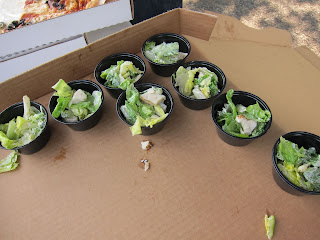 The big surprise for me along the race route came, when I saw there were little bowls of lettuce for the participants to sample. As those who know me can attest, I have a "thing" for lettuce because it is low-calorie, and helps "fill me up".
 In addition, there were samples of freshly-baked pizza along the walk route!! What a deal!!
 This photo shows some walkers as they are on the bridge above Interstate 5. The jagged peak in the background is a landmark along I-5, and is called Black Butte. I am thankful to be able to say my son and I summited that mountain last year, and you can read about that experience in a previous blog I published (It can be seen in the blog archives, under the date of September 10, 2016, and titled "Siskiyou County Expedition")
 In addition to the food/beverage sampling stations that appear every other block along the walking route, there are musical stages set up every other block along the race route. This photo shows a musician using a seldom-seen stringed instrument, accompanied by the traditional violin.
  There are also country/western bands, solo artists, brass musicians, vocalists, and drummers, both Native American and Oriental.
  All of the things I have described in the previous comments explain why it took me so long to finally make it to the FINISH line! I wanted to sample each and every product, and take a photo of each and every exhibit!
 My steps were easily distracted by the activities and foods along the way, which explains why I did not come home with one of these medals!
 When there were so many food and beverage products being handed to participants, there was a potential for litter to desecrate the streets of Mt. Shasta, but this issue was resolved by having refuse containers placed strategically after each sampling table.
 I was especially pleased that the refuse containers were clearly labeled so that plastics could be disposed of separately, and hence more easily recycled.
 The race route goes by the Catholic Church in Mt. Shasta, and every year, that community of believers sponsor a fund-raising pancake breakfast that provides a good excuse to load up on carbs before the race----it's for a good cause!!
 Just like the sign in this photo says,
  And for those who have an emergency that interferes with their smile, there is the Mt. Shasta Ambulance service!
 After the race was over, we went back to my son's house, and he grilled us a delicious, healthy dinner outside. He is shown in this photo, and I am using this opportunity to apologize to him for getting distracted taking photos during this event, that we had intended to walk TOGETHER! After it was over, he told me had spent several minutes concerned, worrying, and wondering where I was (thinking that I had possibly brought on a Reactive Hypoglycemic fainting spell by cramming too much food into my mouth, too fast), because he waited so long at the finish line, with no sign of me. When I told him that I was taking photos and videos of the performers, I think it hurt his feelings that I was more interested in taking photos, than I was in walking with him. Therefore, I am using this experience as the visual aid for one of my First Place 4 Health ( www.FirstPlace4Health.com ) memory verses that says, "Encourage one another daily, as long as it is called "Today," so that none of you may be hardened by sin's deceitfulness." Hebrews 3:13. Instead of concentrating on the precious time I had to spend with my son--the "TODAY"--I was focused on getting photos to write a blog about the event. Perhaps my behavior demonstrates how sin's deceitfulness made me think it was more important to publish a particular blog post, than it was to spend time encouraging my son. Hopefully, I will get another chance, and promise to do things differently next time I get to spend time with him! That is because doing activities with my son gives me "MILES OF SMILES"!! Tricia


